Now for the big time. Georgetown, Great Exuma is known as “chicken harbor” because every year 350 cruising sailboats stop there for winter and don’t dare venture further. Why….because the big scary Atlantic Ocean stands between them and the Caribbean with big waves and wind on the nose.
Of course we don’t appreciate a hard sail either. In order to avoid this, we wait for appropriate “weather windows” to open up to make the “easting” more palatable.
We arrived at Georgetown and prepped the boat for the 250-mile run to the Turks & Caicos. Everything went according to plan, including installing the heat exchanger and solving the engine overheating problem. After a fun night at a local restaurant we woke to flat calm and no seas so we began our motoring east. Our original plan was to spend the first night at Calabash Bay in Long Island, then Rum Cay, Crooked Island, Samana, the Plana Cays and finally Mayaguana before heading into Turks and Caicos. We consulted with Chris Parker who is our weather router. Yes, they have those (a weather router is someone who knows a shitload about the weather where you are going and gives you advice on when to leave and when to stay put to avoid bad weather).

Chris thought that the first two days looked good but the third and fourth day looked a bit sketchy. He suggested we spend two nights at Crooked Island or the Plana Cays before continuing east. We planned on taking that advice. So we took off at 6 am. It was only noon when we reached Calabash Bay on the tip of Long Island and the weather was perfect so we said “screw it – lets go for Rum Cay”. Then three hours later we had almost made it to Rum Cay. The weather was still perfect so we discussed our options. The fact that we could go east in flat water with no drama was too good to be true so we turned south and headed for the south end of Long Island at Clarence Town. This ended up knocking two nights off our trip to Turks and Caicos and it was the best accidental detour a sailboat has every documented (I can’t prove that but I just said it). We spent the night in Clarence Town and it was a great anchorage and restaurant – so all was good. We left early for Pittstown Point in Crooked Island and again motored east in flat water and saw whales and mermaids and again had an awesome day. So far we hadn’t hit a bump so we feel bad calling Georgetown “Chicken Harbor” because we had it easy. Crooked Island was cool, especially the lighthouse which looks like Disney built it to look old. I have never seen anything like it with zero government help or sponsors. It has just been sitting there dilapidating for a century. No signs, no warnings, no chained off areas. Just get in there and check it out – all at your own risk without a hospital for 200 miles. I actually think about this when cruising since it’s my nature to explore and jump off and climb shit.

We woke early again and headed east toward the Plana Cays, which is another one of Columbus’ stops. By the way, I know all about Columbus and I was so excited to go to all his first five landfalls on this trip. I read the personal accounts of all three of his voyages and I read his personal journal with all his daily log entries. It was fascinating! It was amazing to be anchored in these bays where he anchored – possibly in the same spot! Let me tell you, in most of these areas NOTHING HAS CHANGED since he saw it. Zero. Anyway the whole Columbus thing gets me excited. We have a lot in common with the sailing and exploring and allJ although he was a bit more aggressive than us.
We arrived at the Plana Cays two days ahead of schedule. We dropped anchor, put the dinghy in the water and went around looking for a scuba site for the afternoon. We headed 1.5 miles north of the anchorage which was just off the beach. When we turned around to head back to the boat I noticed that the boat was on an elevator.

It looked strange. It was rising and falling 4-6 feet with each passing swell underneath it. Then I noticed the waves starting to break on the beach to the point that we couldn’t land the dinghy. Back to the boat! We sat there looking out the front salon window and realized there was a large north swell coming in which made no sense to me. The prevailing conditions are supposed to be coming out of the east. This anchorage is supposed to be calm, protected by Plana Cay. Always.
This seemed to strange to me. By now it was 2 pm, we had a long ass way to the last island of Mayaguana, and we needed to be there before sundown – so we hauled ass. Now things get even stranger. We are cruising along halfway to Mayaguana and a slight wind appears from the west at about 5-10 knots. Now I started to get the picture. If you aren’t familiar with how the weather works its pretty simple. Hot air rises around the center of the earth and heads north and south to cool the poles. But the earth is spinning pretty fast which creates the Coriolis Effect. This makes the winds around the middle third of the earth flow from east to west. So if you are in this region and its blowing from the west there can only be one explanation. A low pressure system north of you powerful enough to stall the trade winds and turn the wind the opposite direction. Low pressure systems are bad because air wants to run to them very fast and that air is called wind. Wind is funny because we need it and love it unless it’s a bit too much and then we hate it and it makes us feel like shit. Kind of of like alcohol. Wait that makes sense since sailors like both a lot.
So we made it to Mayaguana and dropped anchor as the sun splashes into the water. Dinner, movie, just 55 miles to Turks and Caicos – all good , go to sleep. At 2:30 am we both wake to swells in the harbor and southwest wind picking up. I get a bad feeling about this. Lennie sees it in my face. There is no protection there. There are no other boats there. We are anchored in the middle of nowhere (common in these areas) alone with southwest wind. We need a marina and protection and bad. Keep in mind none of this seemed particularly urgent at the time but I am writing this with hindsight which is as accurate as a GPS fix. So we up anchor at 3 am and make our way out of a shallow harbor with coral heads following our GPS breadcrumbs from the night before (which I never knew what to use that for but wow it came in handy) and we hit open ocean, raised the sails and sailed downwind with the waves at our back all the way to Providenciales in Turks and Caicos. We made it through the reef and into a brand new, beautiful, high-end marina called Blue Haven. From roughing it through a low pressure system to “sailing chic” again.
Sobering thought:
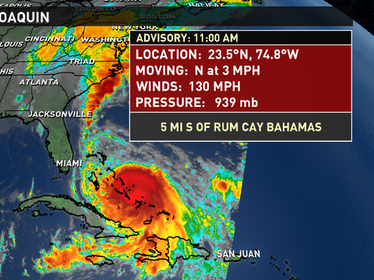 That night, the low pressure system became Category 4 Hurricane Joaquin. It was unexpected, missed by the National Hurricane Center and our weather router because there was no early warning signs. Usually hurricanes can be tracked early from a mass of thunderstorms through eventual development. Joaquin wasn’t on the map until 24 hours before it was deadly. It destroyed all the islands I mentioned above, took the life of people on land and sunk a 755-foot freighter with 33 crew on board – 50 miles from our anchorage at the Plana Cays. If we had stopped at Rum Cay or Calabash Bay or stayed at the Plana Cays we would have been stuck in it with nowhere to run and no safe place for us, or the boat. As it was, we spent three days managing the storm at the dock and protecting the boat with wind gusts up to 45 knots. The storm moved away and the boat was fine and so were we. We have never been that close, and were relieved when it was behind us.
Unfortunately, these beautiful islands were devastated and people’s lives affected. Below are some pictures of the very locations we visited after Hurricane Joaquin.
Scroll down further for the video of the trip.


Glenn Wakefield
Really been enjoying your videos, not just because we are owners of a brand new Leopard 44 either. Been picking up tips from them. We’ve just spent 6 weeks sailing thru the Abacos and Eleuthera. Going to park in the Berries for several months during prime hurricane season while we head home to Utah & Mexico. I’m already getting a rough plan together on our return trip though in the (late) Fall.
Question on your trip south. Looks like you hole up at a decent marina when you guys leave your boat for however long, where did you have it docked at the start of this leg of your trip? I’m having a hard time finding any marinas that look suitable for a nice sailing cat down in the southern islands. Thanks for any info!
PS. Bob Ross loves you guys when I mention your names to him with questions on our new boat :^)
happytogether
Hi Glen, Thanks for watching and congratulations on your cat! Call me anytime to discuss options, upgrades and placed to visit. We need to help each other with this hobby. We have found that the best Marina south of Nassau is Emerald Bay in Georgetown Great Exuma area. You can leave your boat there with great security. That is where we left it for 3 weeks. Next stop is Turks and Caicos marina called IGY Blue Haven. I have great marinas all the way and I wrote about this on a previous blog called how we do it. I recommend you spend the extra few hundred for the higher end marinas. Call me anytime to discuss. Send me email for number. Randy@svhappytogether.com Randy